AccuWeather sees ‘above-active’ hurricane season ahead
'Above-normal' intensity projected as well

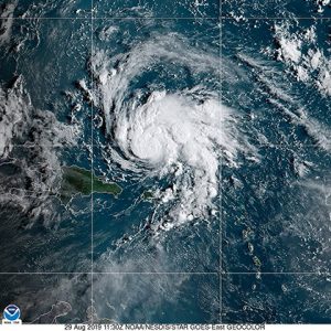
NOAA image of Hurricane Dorian after passing Caribbean islands. NOAA
Last year’s Atlantic hurricane season was legitimately one for the record books, with that time of year approaching once again when storms churn and Floridians prepare for the next five months.
While June 1 marks the official start to the season, top forecasters are beginning to predict what potential impacts could be on the horizon.
AccuWeather’s Global Weather Center and its team of tropical weather experts, led by veteran meteorologist Dan Kottlowski, estimate an above-active season that could result in 16-20 named storms, of which seven to 10 could become hurricanes. They also predict of those hurricanes, three to five could become major hurricanes (Category 3 or higher, maximum sustained winds of 111mph+).
“Current indications are this will be another above-normal season,” said Kottlowski in a release, in his 45th year of issuing forecasts for AccuWeather. “This can translate into high impacts on the United States.”
According to AccuWeather, an “average season” is considered to have 14 named storms, seven hurricanes and three major hurricanes. 2020 saw a record 30 named storms, 13 hurricanes and six major hurricanes.
For just the second time in the modern era, the Atlantic season was depleted of pre-determined names for the season. In mid-September, all 21 names from the English alphabet were used which resulted in the Greek alphabet being administered, the first time that’s happened since 2005.
For the first time since 2012, two named storms formed before the June 1 “official” start to the season, which was a forecast of things to come. Every single named storm other than Tropical Storm Dolly earned the record for the earliest forming storm of that letter in 2020. September proved to be the most active month, as 10 named storms formed over 30 days.
AccuWeather’s team predicts that in 2021, three to five storms will directly impact the mainland U.S., Puerto Rico and the U.S. Virgin Islands (annual average 3.5/year).
As for how intense this season could get, forecasters use a metric called Accumulated Cyclone Energy (ACE) do determine the ferocity of a particular tropical basin. Despite the records, 2020 wasn’t necessarily the most intense season, Kottlowski said. Last year produced an ACE value of 182, which was less than 2017’s total of 225 and pales in comparison to a 245 in 2005.
For 2021, AccuWeather forecasters expect a slightly above-normal season when it comes to intensity. An ACE value of 120-160 is predicted; the 30-year average for Atlantic seasons is 123.
“ACE doesn’t necessarily tell the whole story,” Kottlowski cautioned. “Just because a season has a lower ACE value than another, that doesn’t necessarily mean storms will be less damaging to the United States.”
Often used to paint a picture of the upcoming season is the El Niño Southern Oscillation (ENSO) — whether the waters in the central and eastern Pacific Ocean are warmer or cooler, typically referred to as El Niño (warmer) or La Niña (cooler).
Current forecasts show the existing La Niña pattern to shift to an ENSO-neutral phase by the late spring or early summer, meaning water temperatures in this zone of the Pacific will be closer to average.
Yes, the waters of the Pacific play a major role in the Atlantic hurricane season. Experts say during La Niña patterns, wind shear becomes less prevalent in the atmosphere over the Atlantic.
“Vertical wind shear is one of the biggest inhibitors of development for tropical systems,” Kottlowski said. “When there is less wind shear in the atmosphere, storms can develop with less obstruction. La Niña conditions were present during the height of 2020’s prolific season.”
Time will tell whether the pattern shifts back to a La Niña by the latter part of the hurricane season, according to Kottlowski.
“If that happens, that could certainly increase the chance that we could see more than 20 storms,” he said.
Kottlowski also noted troubling signs already emerging in the western Atlantic, as sea-surface temperatures (SSTs) are above normal in the northern and central Gulf of Mexico. Waters in much of the Caribbean and tropical Atlantic are also warmer than normal or around normal.
As of March 29, water temperatures off Key West were five degrees above normal.
The one exception is the western Gulf of Mexico, where water temperatures by the end of this month were cooler than normal due to the historic Arctic outbreak across the South in February.
“However, those water temperatures are expected to increase by the time the season begins,” Kottlowski said.
There could also be a greater change of a preseason storm to develop this year.
“Our biggest concern is the fact that water temperatures across the Atlantic are already warmer than normal over a larger part of the basin,” Kottlowski said, adding that it won’t take much to make those water temperatures go even higher through the summer and into the peak of the season.
Since 2010, seven Atlantic hurricane seasons have had at least one storm form before the June 1 start date. The last season without any preseason tropical development was 2014.
— Connect with this reporter on Twitter: @haddad_cj


