

Tracking Helene – Wednesday morning update
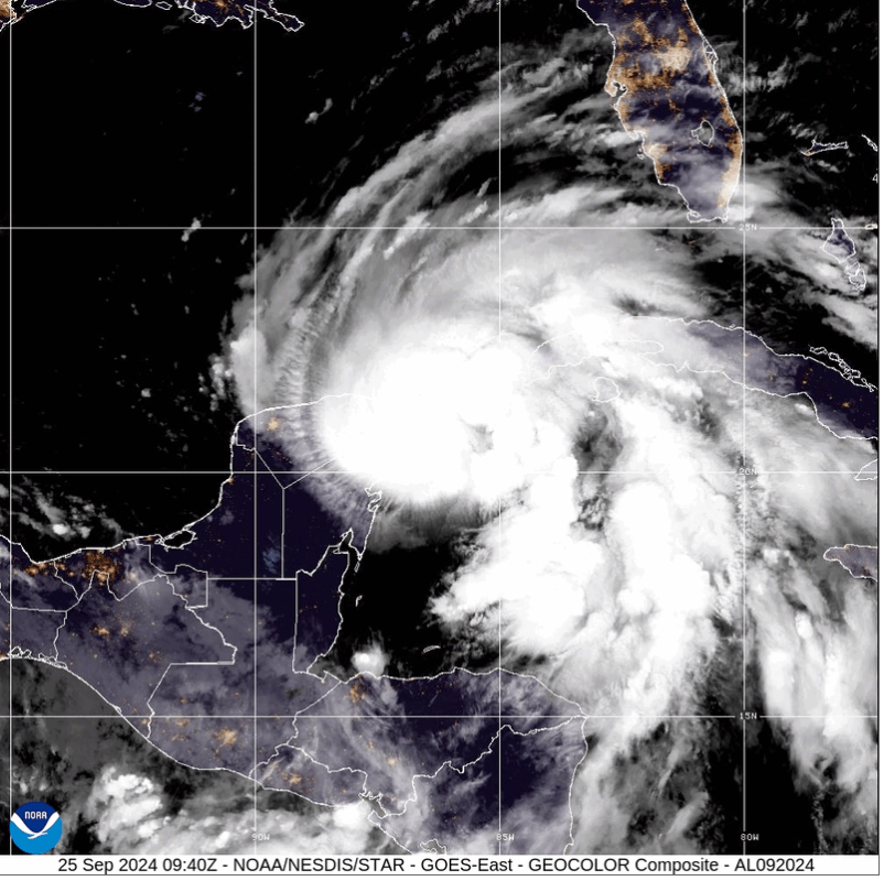
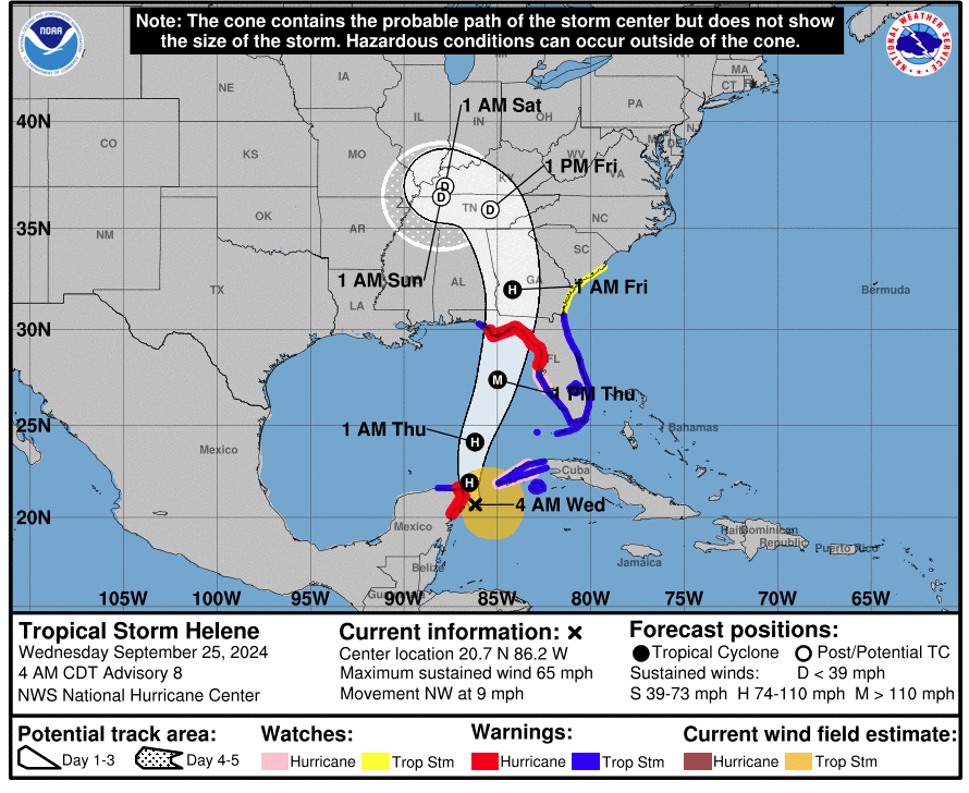
The National Hurricane Center has provided the following updates on Tropical Storm Helene this morning:
A Tropical Storm Warning is now in effect for the Upper Florida Keys from the Channel 5 Bridge to Ocean Reef and for the southern Florida Peninsula east of Flamingo to the Palm Beach/Martin County line.
A Tropical Storm Warning is now in effect for the northeast coast of Florida north of the Flagler/Volusia line to the mouth of the St. Mary’s River.
A Tropical Storm Watch is now in effect for the South Carolina coast north of the Savannah River to the South Santee River.
SUMMARY OF WATCHES AND WARNINGS IN EFFECT:
A Storm Surge Warning is in effect for…
* Indian Pass southward to Flamingo
* Tampa Bay
* Charlotte Harbor
A Hurricane Warning is in effect for…
* Anclote River to Mexico Beach, Florida
* Cabo Catoche to Tulum, Mexico including Cozumel
A Hurricane Watch is in effect for…
* Cuban province of Pinar del Rio
* Englewood to Anclote River, including Tampa Bay
A Tropical Storm Warning is in effect for…
* Dry Tortugas
* All of the Florida Keys
* The Florida west coast from Flamingo to Anclote River, including
Tampa Bay
* West of Mexico Beach to the Walton/Bay County Line
* The Florida east coast from Flamingo northward to the mouth of
the St. Mary’s River
* Lake Okeechobee
* Rio Lagartos to Cabo Catoche, Mexico
* Cuban provinces of Artemisa, Pinar del Rio, and the Isle of Youth
A Tropical Storm Watch is in effect for…
* The Georgia and South Carolina coast north of the mouth
of the St. Mary’s River to the South Santee River
RAINFALL: Tropical Storm Helene is expected to produce total rain accumulations of 4 to 8 inches over western Cuba, the Cayman Islands
and the northeast Yucatan Peninsula, with isolated totals around 12 inches. This rainfall brings a risk of considerable flooding.
Over the Southeastern U.S., Helene is expected to produce total rain accumulations of 5 to 10 inches with isolated totals around 15
inches. This rainfall will likely result in areas of considerable flash and urban flooding, with areas of significant river flooding.
Landslides are possible in areas of steep terrain in the southern Appalachians.
STORM SURGE: The combination of a dangerous storm surge and the tide will cause normally dry areas near the coast to be flooded by
rising waters moving inland from the shoreline. The water could reach the following heights above ground somewhere in the indicated
areas if the peak surge occurs at the time of high tide…
Ochlockonee River, FL to Chassahowitzka, FL…10-15 ft
Chassahowitzka, FL to Anclote River, FL…6-10 ft
Indian Pass, FL to Ochlockonee River, FL…5-10 ft
Anclote River, FL to Middle of Longboat Key, FL…5-8 ft
Tampa Bay…5-8 ft
Middle of Longboat Key, FL to Englewood, FL…4-7 ft
Englewood, FL to Flamingo, FL…3-5 ft
Charlotte Harbor…3-5 ft
WIND: Hurricane conditions are expected in the hurricane warning area in Mexico during the next several hours, with tropical storm
conditions already ongoing. Hurricane conditions are expected within the U.S. hurricane warning area late Thursday. Hurricane conditions
are possible for the western portion of Cuba later today. Tropical storm conditions are expected to begin in the warning area in Cuba
during the next several hours. Tropical storm conditions are expected in southern Florida later today and spreading northward through Thursday. Tropical storm conditions are possible within the tropical storm watch area beginning Thursday and Thursday night.
TORNADOES: A tornado or two may occur tonight over parts of the western Florida peninsula and southern Alabama. The risk of tornadoes will increase on Thursday, expanding across Florida andinto parts of Georgia and South Carolina.
SURF: Swells generated by Helene will affect the southern coast of Cuba and the Yucatan Peninsula of Mexico during the next couple of days. Swells will spread northward toward the west coast of Florida and the northeastern Gulf Coast later today and Thursday. These
swells are likely to cause life-threatening surf and rip current conditions.